
: failed to open stream: Invalid argument in <b>/home/servuzmq/minisites/siteT1/common/template/carteV2.php</b> on line <b>139</b><br />
)
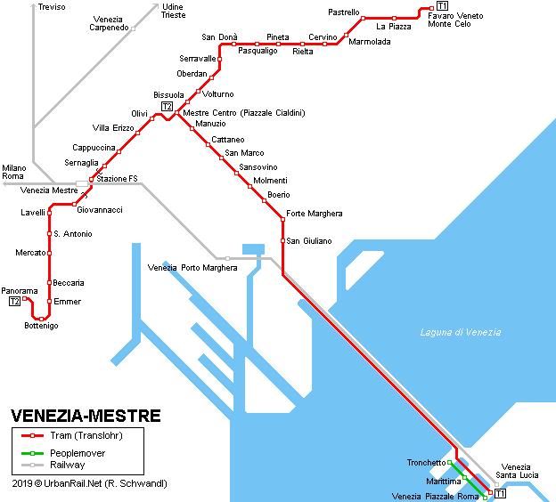
You can find on this page the Venice tram map to print and to download in PDF. The Venice trams map presents the network, zones, stations and different lines of the tramway of Venice in Italy.
The Venice tram map shows all the stations and lines of the Venice tramways. This tramway map of Venice will allow you to easily plan your routes in the trams of Venice in Italy. The Venice tram map is downloadable in PDF, printable and free.
The ACTV's T1 Tramway, which entered service in September, 2015 and runs directly from the northern edge of downtown Mestre to Piazzale Roma on the edge of Venice car-free historic center. (See Venice tramway map) Venice tramway is convenient if you are staying at a hotel near the section of the T1 (red) line between the Piazzale Cialdini and Forte Marghera, which runs mostly along a major street called the Via San Marco.
You do not need special tickets to ride Venice tramway. Just buy ordinary (and cheap) bus tickets from ACTV offices or vending machines, your hotel receptionist, tobacco shops, and newsstands as its mentioned in Venice tramway map. (One Venice tramway ticket can hold multiple fares, so do not be surprised if you ask for several biglietti and receive only one lightweight cardboard card.)
The journey with Venice tramway from Mestre on the mainland is like the railway very cheap, a single ticket costs only 1.50 Euro (in 2020) as you can see in Venice tramway map. For expensive Venice this is areal bargain. Venice tramways run at least every 10 minutes during the day (every 15 minutes on Sundays). The tramways stop in Mestre about 10 times, in Venice only once at Piazzale Roma.