
: failed to open stream: Invalid argument in <b>/home/servuzmq/minisites/siteT1/common/template/carteV2.php</b> on line <b>139</b><br />
)
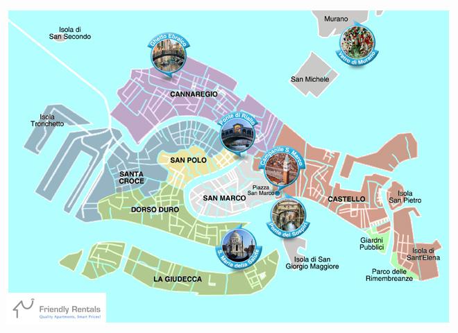
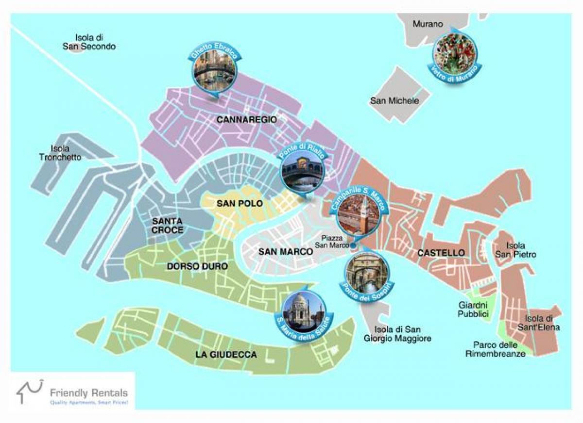
You can find on this page the Venice neighborhood map to print and to download in PDF. The Venice districts map presents quarters, region, suburbs and surrounding area of Venice in Italy.
The Venice neighborhoods map shows region and suburbs of Venice areas. This neighborhood map of Venice will allow you to discover quarters and surrounding area of Venice in Italy. The Venice quarters map is downloadable in PDF, printable and free.
Venice is divided into six sestieri, neighborhoods that have distinctly different characters. San Marco is the central one, surrounded on three sides by a great loop in the Grand Canal as its mentioned in Venice neighborhoods map. Across Rialto Bridge is the artisans neighborhood of San Polo, and across the Grand Canal to the south is stylish Dorsoduro, with its prestigious art museums and lively squares. At the outer edges are Santa Croce, Castello, and Cannaregio, home of the original Ghetto. Beyond the six sestieri - neighborhoods - of the city itself, you'll want to hop aboard a vaporetto to its islands: Lido, Murano, Burano, and Torcello. A fourth island, San Giorgio Maggiore, is worth visiting for the beautiful views of San Marco and Venice from the tower of its church.
The whole comune (English: municipality) di Venezia is divided into 6 municipalità or neighborhoods (English: boroughs) as you can see in Venice neighborhoods map: Venezia (historic city)-Murano-Burano (Venezia insulare), Lido-Pellestrina (Venezia litorale), Mainland (terraferma), Favaro Veneto, Mestre-Carpenedo (Mestre centro), Chirignago-Zelarino, Marghera. A Royal Decree, in 1926, annexed mainland to the comune of Venezia.
The S-shaped Grand Canal, or Canalazzo, snakes through the city, neatly separating the neighborhoods three to a side. The Lido lies to the south of Venice, a sort of barrier island as its shown in Venice neighborhoods map. Cannaregio stretches from the train station to the Rialto Bridge and includes the Jewish Ghetto, a 500-year-old neighborhood that plays a role in Shakespeare “The Merchant of Venice.” This is a quiet, residential neighborhood, unspoiled by much of the tourist crowds in other sestieri.Castello is the largest of the sestiere, stretching from the Rialto Bridge on the west to the Arsenale on the east. It’s one of the quieter neighborhoods; many of the most luxurious hotels are located here.
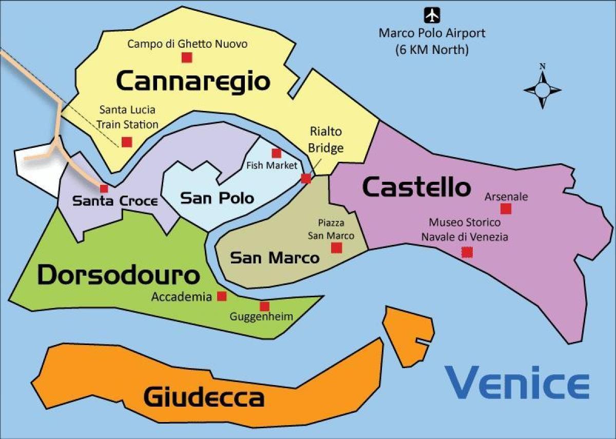
The Venice districts map shows all quarters and suburbs of Venice. This district map of Venice will allow you to discover areas and the region of Venice in Italy. The Venice districts map is downloadable in PDF, printable and free.
The city is divided into six districts or "sestiere" as its mentioned in Venice districts map. These are Cannaregio, San Polo, Dorsoduro (including the Giudecca and Isola Sacca Fisola), Santa Croce, San Marco (including San Giorgio Maggiore) and Castello (including San Pietro di Castello and Sant'Elena). Each sestiere was administered by a procurator and his staff. These districts consist of parishes – initially seventy in 1033, but reduced under Napoleon and now numbering just thirty-eight. These parishes predate the sestieri, which were created in about 1170.
Each sestiere or districts in Venice has its own house numbering system. Each house has a unique number in the district, from one to several thousand, generally numbered from one corner of the area to another, but not usually in a readily understandable manner. At the front of the Gondolas that work in the city of Venice there is a large piece of metal intended as a likeness of the Doge hat. On this sit six notches pointing forwards and one pointing backwards. Each of these represent one of the Sestieri (the one that points backward represents the Giudecca as you can see in Venice districts map).
The old city center of Venice is divided into six districts or sestieri. The Cannaregio district, the most populated, is near the station as its shown in Venice districts map. The Castello district, the largest, and the famous San Marco district, home to its namesake square and basilica, are on the same side of the Grand Canal. The Santa Croce district, the only one with a bridge to the mainland and some car traffic, is across the Grand Canal from the train station. The San Polo district with its famous eponymous church and the Dorsoduro district, situated on Venice's hardest and most stable island, are across the canal from St. Mark.
