
: failed to open stream: Invalid argument in <b>/home/servuzmq/minisites/siteT1/common/template/carteV2.php</b> on line <b>139</b><br />
)
You can find on this page the Venice airports map to print and to download in PDF. The Venice airport map presents terminals and gates of the international airport of Venice in Italy.
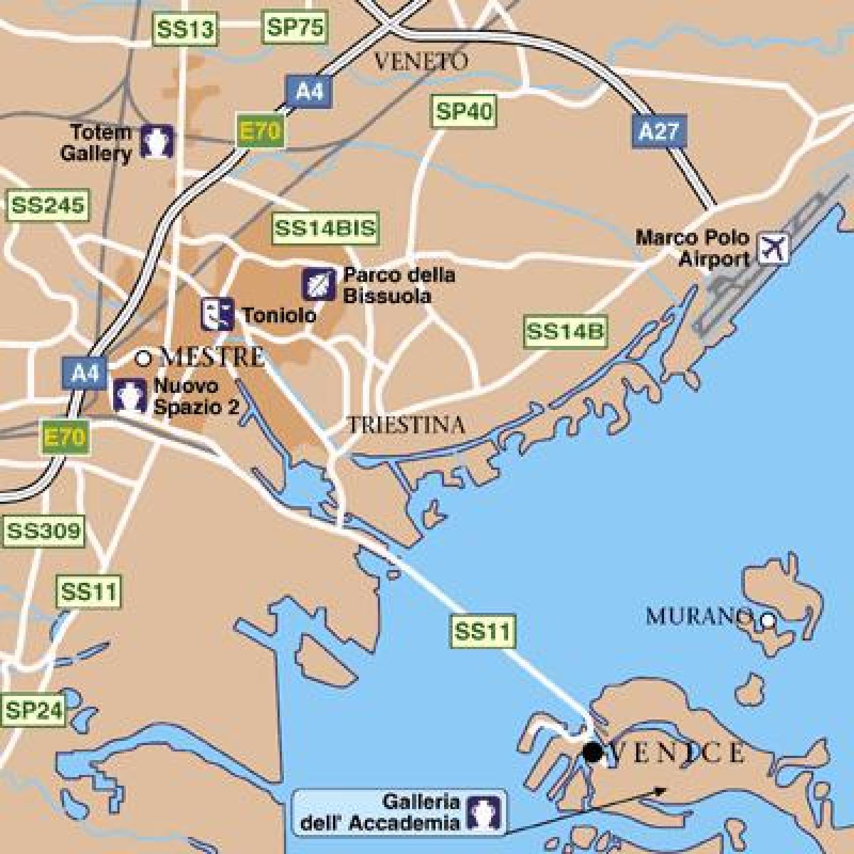
The Venice airports map shows all the airports around Venice. This airports map of Venice will allow you to determine which airport you will used to leave Venice in Italy. The Venice airports map is downloadable in PDF, printable and free.
Venice is served by the Marco Polo International Airport, or Aeroporto di Venezia Marco Polo, named in honor of its famous citizen. The airport is on the mainland and was rebuilt away from the coast. Venice Marco Polo (VCE) is located around six km (four miles) north of the city on the edge of the lagoon as its mentioned in Venice airports map. Venice second airport is Treviso (TSF), 42 km (26 miles) from the historic centre. Generally served by budget airlines such as Ryanair, it is far smaller than its rival.
Some airlines market Treviso Airport in Treviso, 30 km from Venice, as a Venice gateway as you can see in Venice airports map. Some simply advertise flights to "Venice", while naming the actual airport only in small print. To reach Venice from Treviso airport people can catch a public bus from the company ATVO. Venezia Lido, a public airport suitable for smaller aircraft, is found on the NE end of Lido di Venezia. It has a 1000-metre grass runway.
From the Venice airport, it is possible to reach by public transport: Venice Piazzale Roma by ATVO (provincial company) buses and by ACTV (city company) buses (route 5 aerobus as its shown in Venice airports map); Venice, Lido and Murano by Alilaguna (private company) boats; Mestre, the mainland and Venice Mestre railways station (convenient for connections to Milan, Padova, Trieste, Verona and the rest of Italy) by ACTV lines (route 15 and 45) and by ATVO lines; regional destination (Treviso, Padua, beach, ...) by ATVO buses and by Busitalia Sita Nord buses (national company).
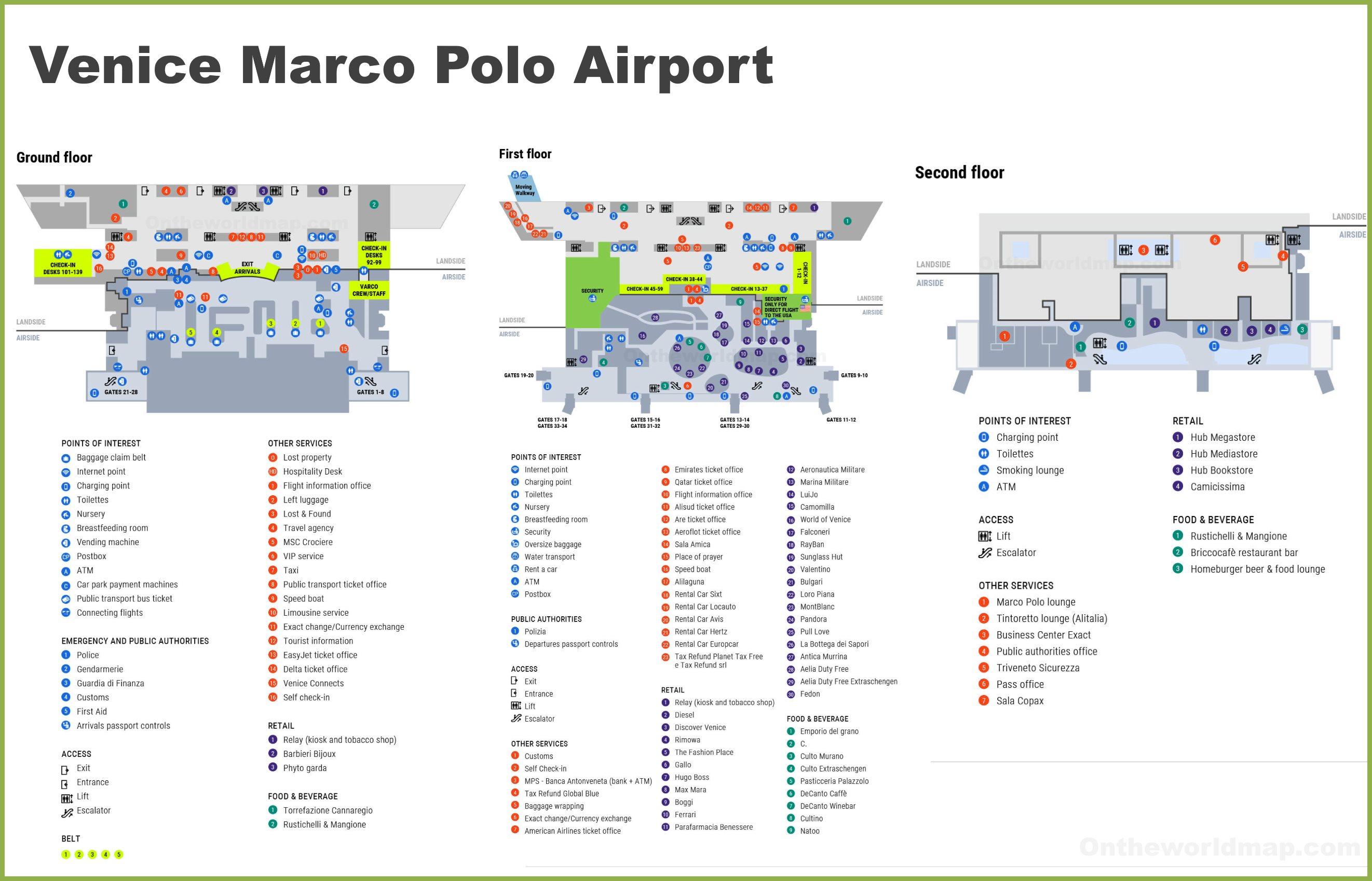
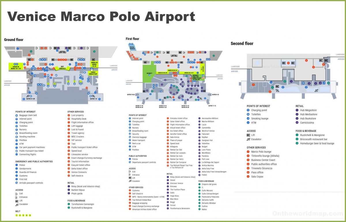
The map of Venice airport presents the main international airport of Venice. This international airport map of Venice will allow you to determine by which terminal and gate you will arrive or leave Venice in Italy. The airport Venice map is downloadable in PDF, printable and free.
With 8,584,651 passengers having passed through Venice international airport in 2011, it is the fourth Italian airport in terms of air traffic. A modern terminal was opened in Venice international airport in 2002 but it is already at full capacity. It handles all scheduled and charter flights, including some long-haul flights to the Middle East and North America as its mentioned in Venice international airport map.
Venice international airport terminal has three floors, the ground floor for arrivals and the first floor for departures as you can see in Venice international airport map. The departure area has 70 check-in desks and has two lounges airside for customers. The two departure lounges are the "Tintoretto Lounge" for SkyTeam customers and the "Marco Polo Room" for customers of all other companies. The third floor of Venice international airport terminal has offices for the operating company and airlines.
Venice international airport is managed by SAVE S.p.A., a company partially owned by local authorities which also controls the smaller Treviso Airport, dedicated mainly to low-cost carriers. Venice international airport is connected to the nearby railway station of Venice Mestre and to the bus terminal of Piazzale Roma in Venice by scheduled bus services; to several destinations in the Venice itself by the Alilaguna water shuttle (Blue, Red and Orange lines); and to Piazza San Marco by the express Gold Line water taxi as its shown in Venice international airport map.
